The info on this page is for OED version 0.8.0. See "Help versions" menu at top of page for other versions.
Admin Map Viewing (Help)
Overview
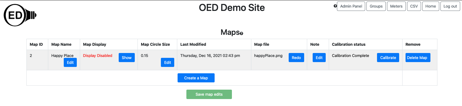
If you are logged in as an admin you can visit the "Maps" page by clicking on the "Maps" button in the top, right
corner of any OED page. You can see and edit information on maps on this page. You can also create a new map as
described on the admin map page. Each column is described below and the next image
shows a sample page. It is
important that you click the "Save
map edits" button at the bottom
of the page to save your changes to the
database if you want users to see this change. Note that the first column with the map
ID will show "(edited)" if a map has been modified but the changes are not yet saved.
Usage
Each column has the following meaning/usage:
- Map ID: This is the internal id used for this map in the database and cannot be changed. It is not usually
of interest but
given in case there is an issue and we need the information to help track it down.
- Map Name: The name displayed and used for selecting this map.
- Map Display: This controls whether regular users can see a map and graph it. If the string is "Display
Enabled" in green with the button "Hide" then users can see this map. If you want to reverse this, click
the "Hide" button so the string becomes "Display Disabled" in red and the button becomes "Show". Clicking
the
"Show" button reverses this again so it is visible to the user. A logged in admin can always see all maps.
New maps are not displayed by default so the admin needs to do this once the map and associated meters are
set up.
- Map Circle Size: This specifies the fraction of the
total map size that the largest circle will be that is displayed on a map and currently defaults to 0.15 or
15% of the map size. This generally works well. However, it
can be suboptimal if items being placed on the map are close together or you want to have larger circles for
viewing.
- Last Modified: This gives the date and time of the last time the map was added or calibrated.
- Map file: This is the name of the image file that was used to create this map.
- Note: You can add any information you want about this map for your records. It is not shown to users.
- Calibration status. Displays "Calibration Complete" if the map has been
calibrated and "Calibration Needed" if the map is not calibrated. Clicking the "Calibrate" button allows you
to do/redo the calibration. See the admin map page for information on map
calibration. Maps must be calibrated before they can be used.
- Remove: Clicking the "Delete Map" button will remove this map from OED. A popup will appear to confirm you
want to remove the map where clicking "OK" removes the map and "Cancel" quits the removal.
Details
None at this time.